today with Rachel, our objective, the the summit of the tallest peak in the entire range:It took us exactly two hours to make the 2,700 foot climb of Mount Peale from La Sal Pass, much of it on huge broken blocks of trachyte porphyry:
Here's the view northwest towards Moab (the green oasis in the bottom of the distant valley in center) from the peak of this laccolithic mountain:
The descent was only marginally faster moving down the sharp-edged scree:
Tuesday, September 7, 2010
Monday, September 6, 2010
Solinst equipment is entirely unreliable...
for monitoring groundwater, as I've just discovered that two more of their LTC loggers have died while deployed in the field. That makes a total of six of eight Solinst loggers that have ceased to function and resulted in months of lost data, a failure rate of 75% based on my experience. Sheesh.
Here's a blog post about their earlier failures, and it doesn't involve battery problems. In addition, I got no satisfaction from their technical support staff, and valuable research data was irretrievably lost.
They have competitors. Use them.
Here's a blog post about their earlier failures, and it doesn't involve battery problems. In addition, I got no satisfaction from their technical support staff, and valuable research data was irretrievably lost.
They have competitors. Use them.
Labels:
gadget,
groundwater,
technology
Sunday, September 5, 2010
Utah's highest waterfall...
captured in action by Moab photographer Tom Till. (Spectacular image at the link.)
Recent intense rainfall provided runoff to the normally dry channel, creating the ephemeral cascade.
Friday, September 3, 2010
Peekaboo Trail...
in the Needles is described as a spectacular hike with "steep slopes and nearby cliff edges that make this a challenging route." So off we went this morning, crossing both Squaw and Lost Canyons, and finally dropping into Salt Creek Canyon:
We ultimately arrived at the end of the long trail, at a small arch and fantastic pictograph panel:
If you look closely, you may notice older Barrier Canyon style paintings behind the most recent:
No, Rachel isn't boasting about how high she can count, but just simply providing a scale for the image at my request, and being expressive:
We ultimately arrived at the end of the long trail, at a small arch and fantastic pictograph panel:
If you look closely, you may notice older Barrier Canyon style paintings behind the most recent:
No, Rachel isn't boasting about how high she can count, but just simply providing a scale for the image at my request, and being expressive:
Thursday, September 2, 2010
Canyon country camping...
is downright pleasant, especially in the summer, when it's usually dry with warm and starry nights. Here's our home for two nights on BLM land a short distance outside the Needles District of Canyonlands National Park:After our hike out to the confluence overlook, Rachel spent the latter part of the day in the hammock, reading her Kindle:
And to prove that I was indeed present, here's my usual self portrait, taken at dusk:
The diffusion boundary...
at the confluence of the Green (entering on the left) and Colorado Rivers, the product of differing suspended sediment loads, is clearly seen at low water:Here's a telephoto shot of the mixing boundary that completely disappears less than a mile downstream:
Wednesday, September 1, 2010
Explorations of Davis Canyon...
just days after heavy rains made it more challenging than usual, as the route into the canyon follows a system of normally dry arroyos:
Recent flash flooding significantly reconfigured the drainages, and kept us from making it all the way to the boundary of Canyonlands National Park. However, beautifully preserved current ripples were everywhere:
We hiked into the Park and up onto the slick rock, finding horizontal burrows weathering out of the Cedar Mesa Sandstone in dramatic relief:
Evidence of the early Anasazi culture are abundant in this part of the Colorado Plateau, and see if you can pick Rachel out of this image of a panel of pictographs:
Recent flash flooding significantly reconfigured the drainages, and kept us from making it all the way to the boundary of Canyonlands National Park. However, beautifully preserved current ripples were everywhere:
We hiked into the Park and up onto the slick rock, finding horizontal burrows weathering out of the Cedar Mesa Sandstone in dramatic relief:
Evidence of the early Anasazi culture are abundant in this part of the Colorado Plateau, and see if you can pick Rachel out of this image of a panel of pictographs:
Signs along the road...
a few miles south of Moab, Utah, painted on the Entrada Sandstone, and impossible to overlook:Upon investigation, the perfect indestructible vehicle for geological field work and dinosaur bone collecting was found parked there:
Saturday, August 28, 2010
The Teva-tan on my feet...
needs some work after having faded during a month at sea, so it's off to Utah for the remaining days of summer.
Friday, August 27, 2010
It's field work Friday...
once again as I resume my regular rounds measuring groundwater levels in monitoring wells in the Rathdrum Prairie, Idaho.
Labels:
groundwater,
idaho
Friday, August 20, 2010
Jetting from Sapporo to Seattle...
today, then a short hop over to Spokane. I'll actually arrive home before I've left as I'll be traveling east across the International Date Line, so time travel is indeed possible.
It will be good to be home after a month at sea, having traveled ~5,000 nautical miles across the northern Pacific Rim, and shooting 3,586 images. As for the highlights, we managed to view a dozen active volcanoes, a couple dozen clam-digging grizzly bears, hundreds of spawning salmon, fur seals by the tens of thousands and seabirds by the hundreds of thousands. It was an awesome trip. It was an amazing experience. It will be good to sleep.
Labels:
pacific rim,
travel,
zegrahm
Thursday, August 19, 2010
Otaru, Japan...
is our final port of call, where both staff and passengers will disembark the Clipper Odyssey tomorrow. After clearance with Japanese customs officials, we spent the afternoon exploring this ancient port city.This shiny place stands in stark contrast to rusty Russia. The old fishing port is known for its Canal District, where glass blowing shops now sell to tourists rather than make glass ball floats for fishing nets:
We visited a sake distillery, and afterward, had a tasting (of course):
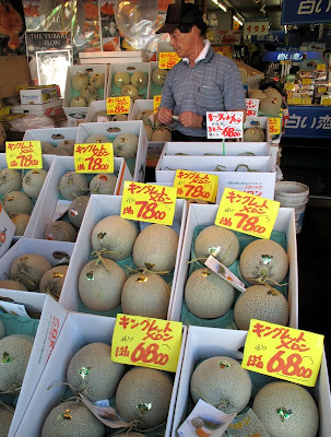
These melons range from $80 to $92 apiece, and are commonly given as gifts:
We visited a sake distillery, and afterward, had a tasting (of course):
These melons range from $80 to $92 apiece, and are commonly given as gifts:
Labels:
pacific rim,
travel,
zegrahm
Wednesday, August 18, 2010
Sakhalin Island...
is the focus of today's explorations as we arrive at sunrise, then board buses for the short drive to Yuzhno-Sakhalinsk, the capital and southernmost major city on this large island:
The natural history museum was my favorite stop, and arguably the nicest structure in all of the Russian far east that we've seen during this voyage:
It's pretty clear what is prohibited on the museum grounds, even though one doesn't speak the language:
Here's smoked sturgeon (4oo rubles/kilo or $6/pound) at the local fish market:
The natural history museum was my favorite stop, and arguably the nicest structure in all of the Russian far east that we've seen during this voyage:
It's pretty clear what is prohibited on the museum grounds, even though one doesn't speak the language:
Here's smoked sturgeon (4oo rubles/kilo or $6/pound) at the local fish market:
Labels:
pacific rim,
travel,
zegrahm
Tuesday, August 17, 2010
Fur seal pups...
are about as cute as can be, and here's a small crèche of them while their mothers go to sea to fish for a couple of days, then return to nurse their young:A few of them cuddled up next to the blind, their flippers extending from under the wooden fence:
And a curious pup with the biggest eyes checks me out:
Labels:
pacific rim,
travel,
zegrahm
Tyuleniy means "seal" in Russian...
so it's highly appropriate that this island rookery share the same name. Tens of thousands of northern fur seals haul out here, and note all of the bobbing heads in the ocean too:Here's a group of Steller's sea lions, much larger than a seal and with blond fur:
Here's a group of fur seals warming in the sun:
I felt like I had a real moment with this one:
Here's a group of fur seals warming in the sun:
I felt like I had a real moment with this one:
Labels:
pacific rim,
travel,
zegrahm
They're called common murres...
and it's not difficult to agree that they are indeed very common on Tyuleniy, a non-volcanic island that consists of folded sandstones rising from the sea:I'll leave it to you to make a headcount, but the murre population is estimated to be approximately 200,000:
Here's an adult murre with a fish for its chick:
And here are a couple of squabbling gulls:
Here's an adult murre with a fish for its chick:
And here are a couple of squabbling gulls:
Labels:
pacific rim,
travel,
zegrahm
This is the welcoming committee...
that met the reconnaissance staff as we head ashore early at Tyuleniy Island, Russia:You'll have to imagine the cacophony of screaming belches and roars from the dozens upon dozens of northern fur seals and Steller's sea lions surrounding the Zodiac:
And here's an image of where we made our landing, at several structures that are occasionally occupied by research biologists that study the ~85,000 pinnipeds and ~200,000 birds that inhabit this tiny island:
Labels:
pacific rim,
travel,
zegrahm
Monday, August 16, 2010
Iturup is the largest...
of the southern Kuril Islands, and the location from which the Japanese launched their attack on Pearl Harbor. Today, however, the island is claimed by Russia, and we visited an old border patrol station and fishing village:
We found enormous bear tracks on tidally exposed beach sands, that is, just a few hours old:
This old fish processing plant is now defunct, but it contained wicker baskets and barrels of salt for preserving salmon:
The weather was sunny and warm, in stark contrast to the day before, and most passengers were happy to be on shore:
We found enormous bear tracks on tidally exposed beach sands, that is, just a few hours old:
This old fish processing plant is now defunct, but it contained wicker baskets and barrels of salt for preserving salmon:
The weather was sunny and warm, in stark contrast to the day before, and most passengers were happy to be on shore:
Labels:
pacific rim,
travel,
zegrahm
Sunday, August 15, 2010
Natalia Bay on Urup Island...
was the site of our morning landing, still in pretty wretched weather, with large fragments of an old Russian tug rusting away on the sandy beach:The bay seems to be eroded into an old cinder cone complex. This outcrop shows a stratified mix of blocks of basalt, pumice and finer tephra:
Perhaps this rainbow that appeared at the time of our departure is a harbinger of better weather ahead:
Labels:
pacific rim,
travel,
zegrahm
Williwaws are defined as...
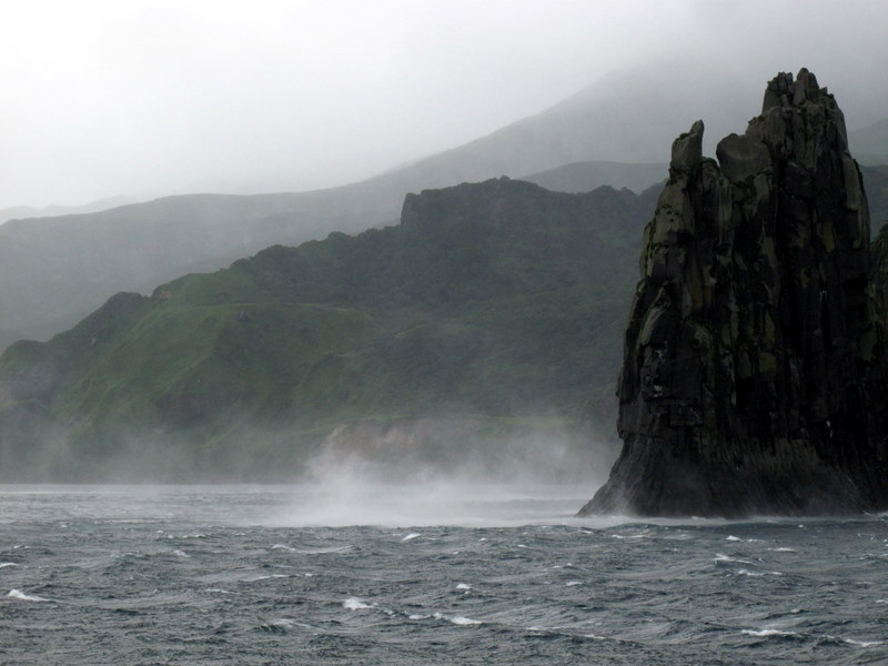
"a sudden blast of wind descending from a mountainous coast to the sea," and we met them in full fury today as we skirted the lee side of an island near the middle of the Kuril archipelago named Chirpoy Brat:
The crosswind to the ship registered an average 35 meters/sec or about 68 knots (~80 miles per hour) for a period of time, and occasionally gusting to 45 m/s or 100 mph!
This resulted in about a 10 degree list of the ship to starboard for much of the morning. Here you can see the spray being whipped up by the fierce winds next to this basaltic sea stack:
The crosswind to the ship registered an average 35 meters/sec or about 68 knots (~80 miles per hour) for a period of time, and occasionally gusting to 45 m/s or 100 mph!
This resulted in about a 10 degree list of the ship to starboard for much of the morning. Here you can see the spray being whipped up by the fierce winds next to this basaltic sea stack:
Labels:
pacific rim,
travel,
zegrahm
Subscribe to:
Posts (Atom)