

Showing posts with label mass wasting. Show all posts
Showing posts with label mass wasting. Show all posts
Sunday, October 30, 2011
Saturday, October 22, 2011
The geohazards field trip...
this Saturday morning was chilly and rainy, but we braved the elements and managed to visit a number of interesting sites in the Spokane area related to mass wasting, stormwater management, stream bank erosion and meander migration.
This image was acquired on a previous field trip, but it illustrates a location where Hangman Creek is impinging on a high cut bank consisting of unconsolidated outburst flood deposits, triggering several slump failures in the 1990s (click to enlarge):
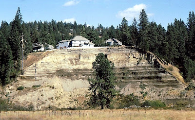
This image was acquired on a previous field trip, but it illustrates a location where Hangman Creek is impinging on a high cut bank consisting of unconsolidated outburst flood deposits, triggering several slump failures in the 1990s (click to enlarge):

Friday, February 4, 2011
Slip slidin' home...
in Coeur d'Alene, Idaho has been abandoned and is of concern to down-slope residents. Here's an oblique view in Google Earth of the physical setting of the subject property (click to enlarge; red X on subject home):


Monday, April 19, 2010
Rocks came tumbling down...

yesterday in Castle Valley, Utah while I was engaged in explorations elsewhere. But my quick thinking neighbor captured this mass wasting event to share with others who may have missed it.
Image credit: JW. Thanks!
Image credit: JW. Thanks!
Tuesday, March 9, 2010
Wednesday, February 17, 2010
A rolling stone...
gathers no moss, destroys outbuildings and shoots through a house in eponymously named Rockville, Utah. Despite considerable property damage it appears that nobody was injured. Here's a good news report and a description of the event from the Utah Geological Survey.
A local witness reportedly commented: "Gravity pulls them [boulders] down, not up."
Yep. It's hard not to agree with that.
A local witness reportedly commented: "Gravity pulls them [boulders] down, not up."
Yep. It's hard not to agree with that.
Tuesday, February 16, 2010
Mudslide in southern Italy...
apparently triggered by heavy rainfall. Cool video and nobody was hurt.
Monday, February 15, 2010
Post mortem to be conducted...
on Naches slide that occurred in October 2009: Geologists search massive Eastern Washington slide for clues.
Previous related posts here and here.
Previous related posts here and here.
Friday, October 30, 2009
Landslide season commences...
in the Seattle area: What homeowners can do to prevent problems. While the primary natural trigger is water-saturated soils, here's a revealing fact from the linked article:
"A city landslide study found that 86 percent of landslides were caused by human activity such as excavation, fill placed on steep slopes, broken pipes and uncontrolled stormwater."Recent years haven't been as bad as the winter of 1996-1997 which this on-line report details: Landslides Triggered by the Winter 1996-97 Storms in the Puget Lowland, Washington.
Tuesday, October 13, 2009
The "Nile Valley Slide"...
 is the name given to the recent mass movement near Naches, Washington by the Washington State Department of Transportation (WSDOT). The slide diverted the Naches River, blocked State Route 410 in Yakima County, and forced the evacuation of several residences. Updated information:
- CNN report with photos and interviews
- WSDOT web site with maps, road status and links to a lot of images and a video
- More local reporting
Sunday, October 11, 2009
Landslide near Naches, Washington...
 occurred this Sunday morning, diverting the Naches River and closing a state highway.
UPDATE: Added image from The Seattle Times (click to enlarge). Credit: Sara Gettys/AP.
Thursday, August 27, 2009
Tuesday, August 25, 2009
Landslide on the Spokane River arm...
of Lake Roosevelt generates waves that destroy a dock at a public boat launch early this afternoon. Sparse initial news reports are here and here, the second story incorrectly refers to the event as a tsunami rather than a seiche.
Here's a better report with video links.
Here's a better report with video links.
Thursday, January 29, 2009
LIDAR technology helps predict...
landslides in Oregon according to this article.
LIDAR is a laser-ranging technology that creates high resolution images of the Earth's surface in stunning detail, stripping away vegetation and showing the underlying terrain. Previously unknown geologic features can be seen clearly, including scarps and slumps, allowing for better understanding of unstable areas.
LIDAR is a laser-ranging technology that creates high resolution images of the Earth's surface in stunning detail, stripping away vegetation and showing the underlying terrain. Previously unknown geologic features can be seen clearly, including scarps and slumps, allowing for better understanding of unstable areas.
Subscribe to:
Posts (Atom)
