
is proceeding at a glacial pace.
Although it's certainly a worthwhile project, in these difficult economic times one should understand that it's not exactly a state or federal funding priority.
Showing posts with label montana. Show all posts
Showing posts with label montana. Show all posts
Sunday, October 9, 2011


Thursday, October 6, 2011
Friday, September 16, 2011
I started walking out at 6 am...
in the dark, using my headlamp to illuminate the trail, after extricating myself from my bivi bag in an early season snowstorm in the Pintler Wilderness. I had solo hiked ~ 9 mi the day before to Oreamnos Lake, situated in a glacial basin immediately astride the Continental Divide, and head of the Pintler Creek drainage. Here's a shot I took upon arrival, with West Pintler Peak standing in the distance (click to enlarge):
 I explored the upper basin in the late afternoon, scouting approaches to tomorrow's climbing objectives, and here's a view back toward the lake, and to East Pintler Peak (bald summit on the left):
 The weather was stable and clear at dinner time, and as my water came to a boil for my freeze-dried meal, I mulled the possible routes to the summits of the two aforementioned peaks:
 As bull elk bugled eerily nearby in the alpine basin, I took this last image at sunset:
 Around 9 pm the stars began to disappear when the wind picked up, as an enormous lightning/thunderstorm rolled over the divide. I was buried in my bivi bag when it began raining heavily, eventually falling asleep in a steady drizzle as the storm waned. Upon wakening in the early morning the precipitation had turned to snow flurries, and I thought it best to head down the mountain, abandoning my climbing goals for another occasion.


Tuesday, September 13, 2011
The road tripping pendulum...
swings back to Montana on this last full week of summer, when I leave this morning for my traditional trip into the Anaconda-Pintler Wilderness near Wisdom. Classes resume at the university a week from tomorrow, so I'm trying to milk at least one last adventure before settling in for fall term. A trip report will follow.
Monday, August 22, 2011
Adventure beckons...
the minute you drive off the pavement east of Yellowtail Reservoir, Wyoming, following gravel roads with challenging 4WD upgrades. That's caving buddy DA in his Baja Bug leading the way into the northern Bighorn Mountains (click to enlarge):
 Two old miner's cabins stand in the near distance, our "camp" for the previous week of caving and other explorations of the area, with the East and West Pryor Mountains looming beyond:
 Pronghorn antelope spied our presence in this out-of-the-way place, never approaching closer than the high ridge overlooking our camp:
 One of our activities involved surface survey for sinkholes in this exhumed karst terrain, but Devil Canyon plunges more than 900 feet from rim to river (Porcupine Creek), an effective geographic obstacle to exploring further north:
 Defunct uranium mines perforate the landscape, where recent but feeble attempts have been made to close the entrances due to safety concerns:
 We went rockhounding one afternoon, and nice specimens of dogtooth spar calcite were found in the mine dumps:
 The nearly sheer walls in Bighorn Canyon show a solutioned zone in the Madison Limestone about 80 to 110 ft below the plateau surface, marking the stratigraphic zone where most caverns had been formed in this area. Note the boaters for scale:
 Nearby, a pair of abandoned channels of the ancestral Bighorn River lie hundreds of feet above the present river level, and are appropriately named the "Natural Corrals:"
 By the way, we ate quite well during our week in residence:
 And every-other evening provided a photo-worthy sunset:


Wednesday, August 17, 2011
Elk Basin oil field...
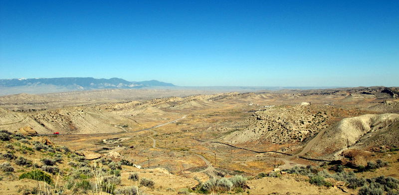
sits astride the Montana/Wyoming border in the northern Bighorn basin and is a breached doubly-plunging anticline (click to enlarge):
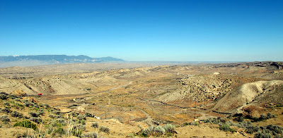 This geologic structure is the site of an actively operating oil field and is used as a three-day mapping exercise for students attending geology field camp at YBRA:
 The historic field is no longer operated by Amoco, but it is still under production:



Tuesday, August 16, 2011
Work week at the YBRA...




It was a certainly a terrific summer in 1978, and a terrific last week visiting with old friends and making new ones, and even taking in the pig races in neighboring Bear Creek one night!
Thursday, August 11, 2011
Another summer road trip...
is about to commence, departing mid-morning tomorrow, consisting of a combination plate of geology, caving and climbing. Packing is underway.
I'll first visit the Yellowstone-Bighorn Research Association (YBRA) geology field station near Red Lodge, Montana. I attended the camp as an undergraduate student in 1978 and still consider it the best six weeks of my early training as a fledgling geologist. This time I'll be volunteering my time to making end-of-season repairs to the facility, including patching the cabins, replacing screens, painting, etc. Other alums will participate (Geogal and her husband will be there) and we'll be well fed by the kitchen staff for all our efforts. I can't wait to hear the camp's dinner bell ring again.
Then I'll proceed to the Bighorn Mountains where I'll meet long-time caving buddy DA to map a recent new discovery. I won't reveal the location, but the cave is in a remote and beautiful spot at the end of a gnarly 4WD road. More people have walked on the Moon than have visited this cavern.
Afterward, I plan to make a three-day solo dash to the summit of Cloud Peak (13,167 ft), the highest in the Bighorn range, and a goal of mine for some time. And finally, I'll boomerang back through Bozeman and visit Zegrahm Expeditions buddy MM (we sailed together last year across the Bering Sea). It will be a fun and active two weeks, and maybe I'll slip in a post now and then.
I'll first visit the Yellowstone-Bighorn Research Association (YBRA) geology field station near Red Lodge, Montana. I attended the camp as an undergraduate student in 1978 and still consider it the best six weeks of my early training as a fledgling geologist. This time I'll be volunteering my time to making end-of-season repairs to the facility, including patching the cabins, replacing screens, painting, etc. Other alums will participate (Geogal and her husband will be there) and we'll be well fed by the kitchen staff for all our efforts. I can't wait to hear the camp's dinner bell ring again.
Then I'll proceed to the Bighorn Mountains where I'll meet long-time caving buddy DA to map a recent new discovery. I won't reveal the location, but the cave is in a remote and beautiful spot at the end of a gnarly 4WD road. More people have walked on the Moon than have visited this cavern.
Afterward, I plan to make a three-day solo dash to the summit of Cloud Peak (13,167 ft), the highest in the Bighorn range, and a goal of mine for some time. And finally, I'll boomerang back through Bozeman and visit Zegrahm Expeditions buddy MM (we sailed together last year across the Bering Sea). It will be a fun and active two weeks, and maybe I'll slip in a post now and then.
Monday, December 6, 2010
A perfect hideaway...
to escape the stress of an increasingly industrialized world: Unabomber's Montana land for sale; 'very secluded'. Hurry! The price has been reduced.
And here's more about the former infamous resident.
Hat tip: the Bu bro.
And here's more about the former infamous resident.
Hat tip: the Bu bro.
Friday, September 17, 2010
It was a Pintlerpalooza...

Tuesday, September 14, 2010
Early winter arrives at Anaconda...

where snow dusts the mountains above the nation's largest superfund site in western Montana (click to enlarge). The historic 585 foot high brick smelter stack can be seen standing in the left center part of the image.
Friday, July 23, 2010
Perfection in the Pintler Range...
can best describe my recent dash to Montana. Forest roads from Moose Lake provided access to a trailhead into the wilderness that allowed for an extended loop hike into the high country. Here's a shot of a typical alpine scene at Phyllis Lake (click to enlarge):
 I was surprised to find the quartzites polished by glacial erosion still contained well preserved sedimentary structures, and here's an excellent set of tabular-tangential crossbeds:
 And some nice ripplemarks:
 Here's my author/professor/ultrarunner gal pal RT casting her gaze across Johnson Lake toward a recent burn in the lodgepole pine forest:


After the ~14 mile (2,200 ft elevation gain/loss) exploration we returned to Rancho Valeo near Missoula to engage in various chores, including repairing a broken bailer (successful!), moving irrigation pipe, and tending to the needs of nine horses. Here's RT being mobbed by several of them:

All for now. Gotta pack for my next adventure to the Bering Sea. A rolling geologist gathers no moss.
Monday, July 19, 2010
Montana bound...
for several days, to visit with friends in Missoula and to explore the north side of the Anaconda-Pintler Wilderness. I'll post a trip report upon my return.
Monday, January 25, 2010
Good for them...
Taking Down the Dinosaur Thief
"A rare and nearly complete dinosaur skeleton stolen from private property in Montana and stored in an evidence locker for more than two years has been turned over to researchers."
Thursday, August 13, 2009
50 year Hebgen Lake earthquake...
anniversary occurs this coming Monday, 17 August 2009. The 7.3-7.5 magnitude event caused the Madison Canyon rockslide, created Quake Lake, killed 28 campers, tilted Hebgen Lake to the north and generated a seiche that nearly eroded the earthen dam, and changed the timing of geysers at Yellowstone National Park.
Here's a recently published historical account in the Bozeman Daily Chronicle.
And a heads up: there will be local programs in the West Yellowstone area to mark the anniversary of the historic temblor.
Here's a recently published historical account in the Bozeman Daily Chronicle.
And a heads up: there will be local programs in the West Yellowstone area to mark the anniversary of the historic temblor.
Friday, June 5, 2009
An image of Earth...
 from space showing Idaho, Montana and Wyoming (click to enlarge.) That's Yellowstone National Park anchoring the center of the image, and if you know your geography one can easily pick out the Spokane valley, lava flows at Craters of the Moon National Monument, the Teton, Wind River and Bighorn mountain ranges, and the Black Hills to name just a few landforms.
Image credit: Jacques Descloitres; MODIS team; NASA, 14 July 2004.
Subscribe to:
Posts (Atom)
