
visualized in an interactive graphic. Adjust the slider at the top of the map to see areas of the globe where the human population ranges from 5 to 500 people per square mile.
It's interesting to note that the continent of Australia doesn't appear at all, even at the minimum density setting, reflecting the sparse human settlement there. And you can see why I love the western interior of the United States.
Showing posts with label maps. Show all posts
Showing posts with label maps. Show all posts
Monday, April 16, 2012


Thursday, March 29, 2012
Dynamic wind map...
traces air flow over the US in near real time based on one-hour differences in barometric pressure. It's zoomable, but I wish you could toggle on/off state boundaries.
Don't stare at it too long. It's hypnotic.
Don't stare at it too long. It's hypnotic.
Wednesday, March 21, 2012
It may look like a pizza...
but it's actually a new map of the surface of Io, one of Jupiter's moons and the most volcanically active body in the solar system:
 More here at the USGS: Geologic Map of Io.
Image credit: Wired.com.

Image credit: Wired.com.
Monday, March 12, 2012
Friday, March 9, 2012
Entire wreck site of Titantic mapped...
in high resolution for first time, showing the 3 x 5 mi (5 x 8 km) debris field in stunning detail, to be released next month on the 100 year anniversary of its sinking on 15 April 1912. Here's a related article that includes some excellent images.
Monday, February 6, 2012
Sea floor now better rendered...
in Google Earth according to this recent announcement. Higher resolution bathymetric surveys have now been incorporated in the image server, showing seamounts, trenches and other features in greater detail than ever before. Take a look, look takers.
Sunday, January 15, 2012
Know your forest biomass...

Can't see the forest for the trees? Now you can.
Wednesday, December 14, 2011
Know your antipode...
before tunneling through the center of the Earth as it may be helpful to have an idea where you will emerge on the other side of the globe. Here's an easy antipode calculator.
For me, digging down from Cheney, America, it's in the southern Indian Ocean, near the Kerguelen Islands.
For me, digging down from Cheney, America, it's in the southern Indian Ocean, near the Kerguelen Islands.
Thursday, December 8, 2011
Thursday, November 17, 2011
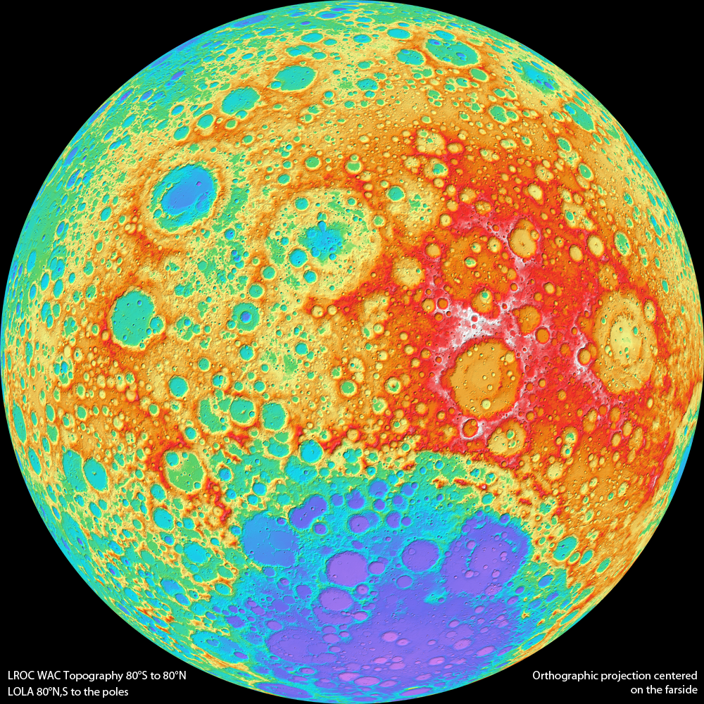
Hi-res topographic map of the Moon...
has just been released (click to enlarge):
 Selenographers rejoice! Here's more information about the new map (and the color scale) and the Lunar Reconnaissance Orbiter Camera.
Friday, March 5, 2010
"Ice Age Floods" layer...
created by former EWU student Ron Hall for Google Earth can be found here. Once you import the .kmz file into GE you can turn on/off or adjust the opacity of glacial lakes, the channeled scablands, glacial ice and significant landmarks.
Great job, Ron.
Great job, Ron.
Thursday, March 4, 2010
Burger wars mapped...
in the US at Weather Sealed. Check out the maps, and indeed, the McForce is strong.
Sunday, January 10, 2010
Smallest map of the world...
has been etched on a chip at 1:1,000,000,000,000 scale, with the "40,000-kilometer equator reduced to 40 micrometers, half the width of a human hair."
Kinda hard to use, however.
Kinda hard to use, however.
Thursday, September 24, 2009
National Geologic Map Database...
can be found at this link and looks like it will be a very useful tool. Here's the description from the web site:
"Welcome to our Data Portal. It is intended to: 1) give you a quick browse and query of our Nation's geologic maps, in a standardized format, and 2) link you to the source information found via the NGMDB Map Catalog and Geologic Names Lexicon. More than 80,000 maps and reports, by 370 publishers, are accessible. We anticipate expanding the Portal this year, and welcome your comments."
Friday, June 26, 2009
New generation of...
digital topographic maps is being offered by the U.S. Geological Survey, called "Digital Map - Beta." Looks good at a glance and I'll give it a test drive when I have the time.
Wednesday, February 4, 2009
Google Mars...

is too cool for school. Here's a screen shot (click to enlarge) of the Olympus Mons region of Mars showing the reference frames for all of the satellite imagery available at this location which, by the way, is the largest volcano in the solar system. The new iteration of Google Earth 5.0 includes this Mars viewer, and this is just the tip of the proverbial iceberg as to its capabilities.
Guess what I'll be exploring the next several weeks?
Guess what I'll be exploring the next several weeks?
Tuesday, February 3, 2009
Geologic Investigations Map...
I-2800 from the U.S. Geological Survey is now in a downloadable form on the web. The map is entitled This Dynamic Planet and it consists of a world map of volcanoes, earthquakes, impact craters, and plate tectonic features. Students will recognize this wall map since it is posted in most of the classrooms and laboratories in the geology department.
Warning: read the web page linked above before you download these huge .pdf files.
Warning: read the web page linked above before you download these huge .pdf files.
Monday, February 2, 2009
Google Earth 5.0 (beta)...
has been released. Here's the link.
Cool content: access to all Mars imagery. More: Google Ocean
Warning: don't download and use this nifty program unless you have a high-bandwidth connection to the net.
Cool content: access to all Mars imagery. More: Google Ocean
Warning: don't download and use this nifty program unless you have a high-bandwidth connection to the net.
Subscribe to:
Posts (Atom)
