have been published for 1 April 2012, and as expected, show that drainage basins in the Pacific Northwest are well above average due to the late season and record-breaking precipitation that occurred in March. But down here, in southern Utah in the heart of the Colorado River basin, runoff is anticipated to be well below average. Typical for a La Niña year, which is exactly what was predicted.
UPDATE: Idaho water supply strong heading to summer. But you already knew that having read this blog post.
Showing posts with label hydrology. Show all posts
Showing posts with label hydrology. Show all posts
Thursday, April 12, 2012


Thursday, March 29, 2012
Time to head to the desert...
since March is now third-wettest on record in Spokane:
Indeed, this is hastening my departure for southern Utah later this week where I'll spend spring term engaged in various research projects during my leave from the university.
UPDATED and BUMPED: Spokane sets March rainfall record. It's official. Soggiest March on record since 1881.
"Spokane recorded 0.62 inch of rain through 5 p.m. today, pushing the total for the month to 3.31 inches. That eclipses last March when 3.25 inches fell. The wettest March was in 1995 at 3.81 inches."Here's a convenient web page showing the flooding status for streams in eastern Washington and northern Idaho.
Indeed, this is hastening my departure for southern Utah later this week where I'll spend spring term engaged in various research projects during my leave from the university.
UPDATED and BUMPED: Spokane sets March rainfall record. It's official. Soggiest March on record since 1881.
Sunday, March 18, 2012
Streamflow forecasts...
for drainage basins in the western US, based on snow pack as of the first of March, can be found here. It shows the Upper Columbia Basin with near normal to above average conditions, while the Sanpoil and Kettle River basins seem to be lagging at 70-89% of normal.
The map does not incorporate the considerable precipitation that has occurred during the month of March. Stay tuned, and I'll post it when it becomes available.
The map does not incorporate the considerable precipitation that has occurred during the month of March. Stay tuned, and I'll post it when it becomes available.
Friday, March 16, 2012
It's field work Friday...
yet again, and I'll head out the door shortly for the Rathdrum Prairie in Idaho to check groundwater levels in the aquifer. There's a torrential downpour going on so it's a good day for recharge, but not so great for field work.
Friday, February 10, 2012
It's field work Friday...
again on a foggy mid-winter morning as I head out to check groundwater levels in the Rathdrum Prairie aquifer. I need to remember to check the current snowpack reports for the Selkirk Mountains to see what to expect in the runoff (recharge) season ahead.
RELATED: Here's the streamflow forecast map as of 1 February 2012 for the western US. Looks like the snowpack in the Spokane River basin lies between 70 - 109% of normal, depending on specific location in the watershed.
RELATED: Here's the streamflow forecast map as of 1 February 2012 for the western US. Looks like the snowpack in the Spokane River basin lies between 70 - 109% of normal, depending on specific location in the watershed.
Monday, February 6, 2012
Visualization of an ancient ocean...
on Mars courtesy of the European Space Agency, using the MARSIS instrument on their Mars Express spacecraft (click to enlarge):
 Here's the press release with more information.
Image credit: ESA.

Image credit: ESA.
Friday, January 13, 2012
It's field work Friday...
again, the first of the year. After completing my monthly rounds measuring groundwater levels in the Rathdrum Prairie aquifer, I'll head over to Wolf Lodge Bay on Lake Coeur d'Alene to see if the bald eagles are still hanging out.
I also note that it's Friday the 13th, so I'll be extra careful during my field activities today.
I also note that it's Friday the 13th, so I'll be extra careful during my field activities today.
Friday, December 9, 2011
It's field work Friday...
today, the last of the calendar year, as I check the dipsticks in the Rathdrum Prairie aquifer.
Sunday, October 30, 2011
The regulated plumbing system...
that we call the Columbia River: The High-Stakes Math Behind the West's Greatest River.
Friday, September 23, 2011
It's field work Friday...
after a binge of extensive summer travel, where I missed making groundwater level measurements on the Rathdrum Prairie, Idaho, during the month of August. Time to get back into the monthly routine.
Thursday, August 4, 2011
Seasonal slope streaks...

While the phenomenon of slope streaking on crater walls on Mars is not news in and of itself, the periodic, seasonal appearance of these is exceptionally well documented. Furthermore, this evidence reduces the likelihood that they are a result of a mass wasting mechanism, such as dry grain flow. Very exciting stuff, for a geek.
More at the JPL web site, and here's the technical abstract.
Saturday, June 4, 2011
The BNSF Railway re-fueling depot...
at Hauser, Idaho was a controversial project when it was proposed and built, especially since it lies atop the Spokane Valley - Rathdrum Prairie sole source aquifer. Two tanks hold a total of 500,000 gallons of diesel fuel to dispense to locomotives along the main rail line (click to enlarge):
The fuel is brought to the facility in 30,000 gallon tank cars that are individually off-loaded to the larger storage tanks seen above:
My environmental science seminar students toured the complex today in order to examine the environmental protections integrated into the facility. Above ground storage tanks, double-lined piping, epoxy-sealed concrete platforms with two HDPE liners beneath them, are all designed to minimize accidental releases to the underlying aquifer. Special thanks go to BNSF for allowing us to visit the operating industrial facility.
The fuel is brought to the facility in 30,000 gallon tank cars that are individually off-loaded to the larger storage tanks seen above:

My environmental science seminar students toured the complex today in order to examine the environmental protections integrated into the facility. Above ground storage tanks, double-lined piping, epoxy-sealed concrete platforms with two HDPE liners beneath them, are all designed to minimize accidental releases to the underlying aquifer. Special thanks go to BNSF for allowing us to visit the operating industrial facility.

Friday, June 3, 2011
Field work Friday...
on the Rathdrum Prairie, Idaho yielded groundwater level measurements showing the highest water table elevation in the aquifer in the past decade. It's a great year for aquifer recharge.
Friday, May 20, 2011
32,400 cubic feet per second...
of spring runoff is pouring over Spokane Falls this afternoon (click to enlarge):
 It's impossible to cross on the foot bridges without catching some spray, and on this nice afternoon there were quite a few people enjoying the experience:
 For comparison, the average flow on this date based on 120 years of record is 18,200 cfs.


Thursday, May 19, 2011
Spokane River rises to flood stage...
as snowmelt and spring runoff continues. Here's the real-time gaging information for USGS 12422500 SPOKANE RIVER AT SPOKANE, WA.
RELATED: The early May snowpack in the basin is between 130 to more than 180 percent of normal this year.
RELATED: The early May snowpack in the basin is between 130 to more than 180 percent of normal this year.
Saturday, May 14, 2011
Man-made deluge commences...
in the Atchafalaya River basin as the Morganza Floodway is activated for the first time in 38 years: Mississippi River Floodgate Opens, Inundating Cajun Country in Louisiana.
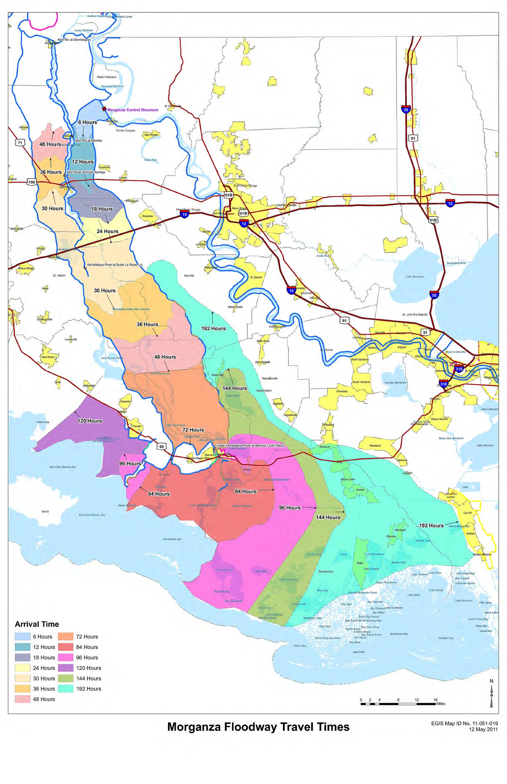
Here's the forecast map issued by the U.S. Army Corps of Engineers that indicates the timing of flooding downstream from the spillway. Sadly, family members of a good friend and colleague reside in the affected area.
RELATED: How It Works: The Spillways Trying to Control the Rising Mississippi
Here's the forecast map issued by the U.S. Army Corps of Engineers that indicates the timing of flooding downstream from the spillway. Sadly, family members of a good friend and colleague reside in the affected area.
RELATED: How It Works: The Spillways Trying to Control the Rising Mississippi
Thursday, May 12, 2011
Images of Earth from space...

showing spring flooding in the U.S. Midwest and Canada, organized and indexed at the NASA Earth Observatory. Follow the link to access continuously updated satellite imagery related to this slow motion catastrophe.
Tuesday, May 10, 2011
Heartbreaking inundation...
captured in a photo-essay: The Big Picture: Mississippi River Flooding.
RELATED: Here's an excellent historical and semi-technical summary of efforts to control the nation's largest river system: Evolution of the Levee System Along the Lower Mississippi River (~9 MB .pdf file).
RELATED: Here's an excellent historical and semi-technical summary of efforts to control the nation's largest river system: Evolution of the Levee System Along the Lower Mississippi River (~9 MB .pdf file).
Friday, May 6, 2011
Near historic flooding at the confluence...
of the Ohio and Mississippi Rivers, shown in satellite images comparing normal versus present-day conditions, can be seen at NASA's Earth Observatory web site. Be sure to read the excellent description accompanying the images.
Thursday, March 31, 2011
2011 Darcy Lecturer in Spokane...
next week, speaking about salt water intrusion in the Godomey aquifer, Cotonou, Benin, West Africa. The lecture is free and open to the public:
Thursday, April 7th, 2011, 5:30—7 pm
Dr. Steve Silliman
Gonzaga University, Jepson 108
Dr. Silliman directs a research program to manage the sole‐source aquifer for the 2 million people of Cotonou, Benin. The groundwater wells serving this population are located about 6 km north of the Atlantic coast and as close as 1 km to a large lake, and withdraw water from partially confined portions of this complex aquifer system. This vital water resource is threatened by saltwater intrusion from the lake and the ocean, and anthropogenic contamination. The presentation will cover numerical modeling, hydraulic testing, water quality characterization, and electrical resistivity surveys. Discussion of a number of technical and social/cultural issues encountered during this research effort illustrates the value of close cooperation with in‐country collaborators in technical and social science disciplines.
Subscribe to:
Posts (Atom)