visualized in an interactive graphic. Adjust the slider at the top of the map to see areas of the globe where the human population ranges from 5 to 500 people per square mile.
It's interesting to note that the continent of Australia doesn't appear at all, even at the minimum density setting, reflecting the sparse human settlement there. And you can see why I love the western interior of the United States.
Showing posts with label earth. Show all posts
Showing posts with label earth. Show all posts
Monday, April 16, 2012


Sunday, April 1, 2012
Journey to the center...

Tuesday, March 27, 2012
Shuttle Atlantis over Tenerife...
in the Canary Islands, as photographed during a previous mission from the International Space Station (click image for high res version):
 North is to the left in the image, and you can clearly see the Pico del Teide volcano within the Las Cañadas caldera through the break in the clouds over the island.
Personal note: I'll be exploring Tenerife and the volcanic edifice seen here in about five weeks time with Zegrahm Expeditions as their geologist lecturer/guide. I'm getting excited.

Personal note: I'll be exploring Tenerife and the volcanic edifice seen here in about five weeks time with Zegrahm Expeditions as their geologist lecturer/guide. I'm getting excited.
Wednesday, March 7, 2012
You've been warned this would happen...
and this is just a tiny one: Solar storm headed toward Earth may disrupt power.
Not to say I told you so, oh heck, yes I will. You will find two previous posts about this serious hazard here and here.
Not to say I told you so, oh heck, yes I will. You will find two previous posts about this serious hazard here and here.
Monday, March 5, 2012
Saturday, March 3, 2012
Mars is at opposition...
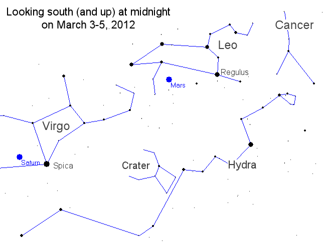
this weekend, meaning that the Earth and the red planet are in alignment on the same side of the Sun, and it's also the closet the two planets will approach each other in 2012. Here's a map view of the solar system showing the positions of all the planets, and a sky map if you want to go out around midnight and locate it in the night sky. Look toward the south and up, and it'll be the bright red object in Leo. (Here's a more advanced sky map if you want to track the motion of Mars over the next few months and into late summer.)
NOTE: Just a little east of Mars, Saturn will be glowing bright yellow in Virgo, very near the hot white-blue star Spica.
NOTE: Just a little east of Mars, Saturn will be glowing bright yellow in Virgo, very near the hot white-blue star Spica.
Monday, February 6, 2012
Sea floor now better rendered...
in Google Earth according to this recent announcement. Higher resolution bathymetric surveys have now been incorporated in the image server, showing seamounts, trenches and other features in greater detail than ever before. Take a look, look takers.
Wednesday, February 1, 2012
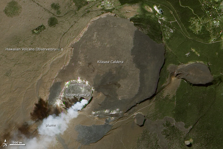
An image of Earth from space...
celebrating 100 years of volcano monitoring at Kiluea, showing a vigorous plume rising from Halemaʻumaʻu Crater (click to enlarge):
 Learn more about this image, and download a high-res version, at NASA's Earth Observatory.
Friday, January 27, 2012
Google upgrades Earth...
with significantly better rendering, doing away with the patchwork quilt resulting from imagery from different sources. More here: Google Releases Pretty Earth.
Wednesday, January 25, 2012
Highest resolution image...
of Earth ever compiled, using the VIIRS instrument aboard NASA's most recently launched Earth-observing satellite - Suomi NPP - has just been released:
 You can access other resolutions of this fantastic image at this link for free download. The original 8,000 x 8,000 pixel image is stunning to say the least, but it is an enormous file.

Wednesday, December 14, 2011
Know your antipode...
before tunneling through the center of the Earth as it may be helpful to have an idea where you will emerge on the other side of the globe. Here's an easy antipode calculator.
For me, digging down from Cheney, America, it's in the southern Indian Ocean, near the Kerguelen Islands.
For me, digging down from Cheney, America, it's in the southern Indian Ocean, near the Kerguelen Islands.
Tuesday, November 15, 2011
Monday, November 14, 2011
Wednesday, November 17, 2010
Monday, October 4, 2010
An image of Earth...

Image credit: Astronaut photograph ISS024-E-14071 taken 9 September 2010; NASA, Johnson Space Center.
Monday, March 15, 2010
Something to consider...
when founding your dynasty: Orange Dwarf Star Confirmed to be On Collision Course With Earth. We're all gonna die:
"Our solar system's 'hood may get a bit rougher sometime during the next 1.5 million years. An astronomer has given an 86 percent chance for a neighboring star to smash into the frozen Oort Cloud surrounding the outskirts of the solar system, and may scatter some comets toward Earth."More here. Stay calm. Don't panic.
Friday, March 5, 2010
"Ice Age Floods" layer...
created by former EWU student Ron Hall for Google Earth can be found here. Once you import the .kmz file into GE you can turn on/off or adjust the opacity of glacial lakes, the channeled scablands, glacial ice and significant landmarks.
Great job, Ron.
Great job, Ron.
An image of Earth...
 from space showing snow blanketing much of the western US on 23 February 2010 (click to enlarge). I'll leave it to you, dear reader, to figure out the geography.
Image credit: MODIS on NASA’s Terra satellite.
Tuesday, February 23, 2010
Breathtaking images of Earth...
 made available: The Most Accurate, Highest Resolution Earth View to Date. Be sure to click on the image for the high res version.
Saturday, February 6, 2010
Commercial jet caught in flight...

Apparently I'm not the first to spot various aircraft in flight in GE.
Oh yeah, that's the Slick Rock Member of the Entrada Sandstone and the overlying members of the Morrison Formation in outcrop, and some modern eolian dunes.
Subscribe to:
Posts (Atom)