Monday, September 19, 2011

Cursed canyon?

Amos Richards saved after crawling 4 days across Utah desert in the same canyon where Aron Ralston amputated his arm in May 2003.

RELATED:  I visited Blue John Canyon in spring 2006 with EWU geology grad JL and his girlfriend.  Here's JL in one of the larger, upper parts of the slot canyon (click to enlarge):
It's a fascinating and sporting canyon system, with enormous chockstone boulders lodged seemingly dangerously overhead in many places.  If this were a Road Runner cartoon the Wile E. Coyote would almost certainly be guillotined by one of these babies:
This narrow section is below, but very close to, where Aron cut his arm off to free himself after five days of entrapment by a rotating chockstone:
At the end of the slot one emerges onto one of the coolest ledges in canyon country, where a 70 ft rappel must be rigged in order to continue down canyon.  Imagine doing this with only one arm after you've just amputated the other:
About six miles further down canyon you pass through the Horseshoe Canyon section of Canyonlands National Park, passing the Grand Gallery, one of the finest rock art panels on the Colorado Plateau:
It's clear why this is a popular canyon to explore, but solo hikers should be (1) extra cautious and (2) let others know their plans.  I certainly do.

Friday, September 16, 2011

I started walking out at 6 am...

in the dark, using my headlamp to illuminate the trail, after extricating myself from my bivi bag in an early season snowstorm in the Pintler Wilderness.  I had solo hiked ~ 9 mi the day before to Oreamnos Lake, situated in a glacial basin immediately astride the Continental Divide, and head of the Pintler Creek drainage.  Here's a shot I took upon arrival, with West Pintler Peak standing in the distance (click to enlarge):
I explored the upper basin in the late afternoon, scouting approaches to tomorrow's climbing objectives, and here's a view back toward the lake, and to East Pintler Peak (bald summit on the left):
The weather was stable and clear at dinner time, and as my water came to a boil for my freeze-dried meal, I mulled the possible routes to the summits of the two aforementioned peaks:
As bull elk bugled eerily nearby in the alpine basin, I took this last image at sunset:
Around 9 pm the stars began to disappear when the wind picked up, as an enormous lightning/thunderstorm rolled over the divide.  I was buried in my bivi bag when it began raining heavily, eventually falling asleep in a steady drizzle as the storm waned.  Upon wakening in the early morning the precipitation had turned to snow flurries, and I thought it best to head down the mountain, abandoning my climbing goals for another occasion.

Tuesday, September 13, 2011

The road tripping pendulum...

swings back to Montana on this last full week of summer, when I leave this morning for my traditional trip into the Anaconda-Pintler Wilderness near Wisdom.  Classes resume at the university a week from tomorrow, so I'm trying to milk at least one last adventure before settling in for fall term.  A trip report will follow.

Saturday, September 10, 2011

Congratulations to Robin and Tom...

who were wed on this day at noon in southern Oregon, and for whom I conducted the marriage ceremony!  A terrific time was had by the ~75 family and friends in attendance (there was a strong showing by EWU biology and geology faculty), and I'll post some pics as soon as I receive them from friends.

UPDATE:  Here are a couple of pics of the ceremony, courtesy of Eric Wesselman (click to enlarge):
Even Freya was spellbound as Robin emotionally recited her vows:

Thursday, September 8, 2011

Two volcanoes in two days...

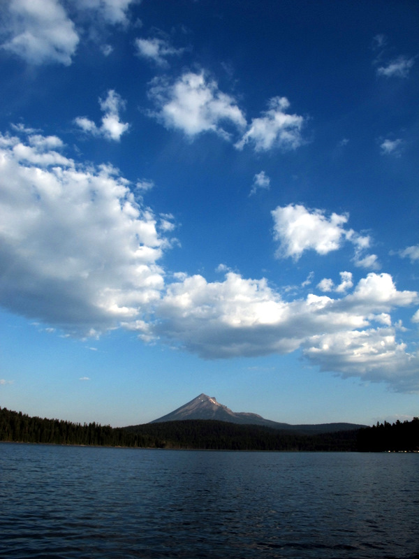
was my goal, so I set my sites on Mount McLoughlin today, seen here to the north across Lake of the Woods:
The sign at the trailhead offers guidance and warnings to the casual visitor, as this is indeed an arduous hike that climbs ~ 4,100 ft over 5.5 mi (though there are no technical challenges on the route):
Once you emerge from the trees the summit comes into view, but still more than a mile away and a thousand feet higher:
By noon I was on top and enjoying commanding vistas of Upper Klamath Lake (upper right) and Fourmile Lake (center left) where I spent the night before:
And here's a self portrait after I descended a short distance from the summit to eat a snack, with an attempt at pointing out where I came from:

Wednesday, September 7, 2011

The "lighning rod of the Cascades"...

is a nickname assigned to Mt. Thielsen, and perhaps you can see how it's earned this distinction in this view with Diamond Lake in the foreground (click to enlarge):
The sunrise the morning of my solo dash to the summit was spectacular, a harbinger of the great experience that awaited me on the West Ridge route:
Once I emerged from the trees and climbed above the Pacific Crest Trail, the volcanic geology of the mountain presented itself in stunning outcrops:
The last couple of pitches, although Class 4 grade, are real butt-puckerer's (if you know what I mean), especially given the extraordinary exposure of the summit block.  Here's the view to the south, catching a bit of the remaining rim of Mt. Mazama (Crater Lake) in the distance, with my toes at the bottom of the image:
And here's a shot to the north, looking pretty much straight down to the Lathrop Glacier, about 1,200 ft below me:
On the descent I examined an area where, in the recent past, a strong wind has blown down a swath of the forest, uprooting hundreds of large trees:
It's a wonder that they can find any purchase at all in the deep, pumiceous soils around the lower part of the mountain:

Monday, September 5, 2011

'Tis the eve of my next road trip...

that embarks tomorrow morning and I am busily back-posting several entries related to my recent travels to Montana and Wyoming.  Scroll down to catch the latest, albeit tardy, entries.  Apologies for the delay in getting these posts published, but consulting projects, home chores and university business held greater priorities this last week in residence.

So, what's the plan for the next excursion?  Tomorrow I head for Oregon with intentions of climbing a couple of volcanoes along the way, Mt. Thielsen on Wednesday and Mt. McLoughlin on Thursday, then ultimately landing at my friends' wedding near Klamath Falls over the weekend that I've been asked to officiate.

Fun and challenging, all around.  Stay tuned for a post-trip report, and a considerably more timely one this time around.

Sunday, August 28, 2011

Wise words...

found on a dirty window in a cabin used by cavers, somewhere in the Bighorn Mountain range, north-central Wyoming (click to enlarge).

Saturday, August 27, 2011

I'm back at the roost...

after a two week-long road trip that was good for the soul.  I'll back-post some of the highlights (climbing, caving, wildlife, etc.) after I tend to some homecoming chores.

Friday, August 26, 2011

My walk in the Cloud Peak Wilderness...

began at the West Tensleep Lake trailhead, traversing a well-worn path for about 10 miles through glacial moraines (click to enlarge):
Wildflowers were thriving in the high altitude and provided colorful distraction from my burdensome backpack, loaded for three days alone in the back country:
This view toward the northeast, from the shores of Lake Helen, provides the first glimpse of the west ridge route to the summit of Cloud Peak (13,167 ft):
I bivied a short distance away from this 40 ft waterfall for two nights, preparing my meals alongside the stream so that odors wouldn't draw bears to my camp:
I started toward the summit at around 8 am (a tad bit late), navigating a ~3 mile scramble/hike over seemingly relentless boulder fields, gaining more than 3,200 ft along the way.  Here's a snap of the highest blooming plant (Parry's primrose) that I encountered on the west ridge:
I arrived at the lofty summit around 1 pm, taking the requisite self portrait.  That's Glacier Lake, more than 1,800 ft below me, on the east side of the peak:
Another view from the summit shows numerous alpine lakes in a glacially-denuded basin to the north:
Pikas were everywhere in the boulders at mid to lower elevations, and provided near constant companionship on my solo hike:
On the final morning, during my hike out, I encountered two wary moose near Mistymoon Lake:
And here's the last picture I took, gazing back toward my now accomplished objective, as I left the magnificent wilderness:

Monday, August 22, 2011

Adventure beckons...

the minute you drive off the pavement east of Yellowtail Reservoir, Wyoming, following gravel roads with challenging 4WD upgrades.  That's caving buddy DA in his Baja Bug leading the way into the northern Bighorn Mountains (click to enlarge):
Two old miner's cabins stand in the near distance, our "camp" for the previous week of caving and other explorations of the area, with the East and West Pryor Mountains looming beyond:
Pronghorn antelope spied our presence in this out-of-the-way place, never approaching closer than the high ridge overlooking our camp:
One of our activities involved surface survey for sinkholes in this exhumed karst terrain, but Devil Canyon plunges more than 900 feet from rim to river (Porcupine Creek), an effective geographic obstacle to exploring further north:
Defunct uranium mines perforate the landscape, where recent but feeble attempts have been made to close the entrances due to safety concerns:
We went rockhounding one afternoon, and nice specimens of dogtooth spar calcite were found in the mine dumps:
The nearly sheer walls in Bighorn Canyon show a solutioned zone in the Madison Limestone about 80 to 110 ft below the plateau surface, marking the stratigraphic zone where most caverns had been formed in this area.  Note the boaters for scale:
Nearby, a pair of abandoned channels of the ancestral Bighorn River lie hundreds of feet above the present river level, and are appropriately named the "Natural Corrals:"
By the way, we ate quite well during our week in residence:
And every-other evening provided a photo-worthy sunset:

Wednesday, August 17, 2011

Elk Basin oil field...

sits astride the Montana/Wyoming border in the northern Bighorn basin and is a breached doubly-plunging anticline (click to enlarge):
This geologic structure is the site of an actively operating oil field and is used as a three-day mapping exercise for students attending geology field camp at YBRA:
The historic field is no longer operated by Amoco, but it is still under production:

Tuesday, August 16, 2011

Work week at the YBRA...

took me back in time to my six week stay at the historic field station during my field camp experience in summer 1978.  Little has changed in the vista seen from its mountainside locale above Red Lodge, Montana, where you can observe nearly vertically-dipping Paleozoic strata that define the Beartooth Front (click to enlarge):
I spent the last four days in various repair tasks, first of which was scraping and painting one of the two study halls.  Here's a shot of JR working away while I supervise, take pictures, and offer encouragement:
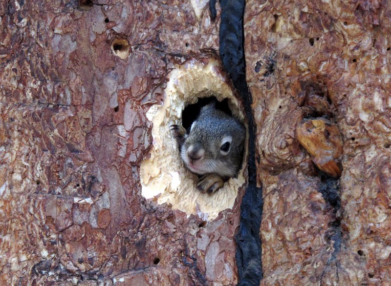
I probably repaired (closed) more than three dozen squirrel holes chewed into the sides of the many cabins scattered throughout the camp.  I had to patiently wait for this fellow to leave before I screened off the hole, but I needed a break anyway:

The last day was spent assisting JR in replacing the old wooden and warped front door to the main lodge with a more robust metal door better able to endure the winter elements (and bears):
On the last day I found our 1978 class picture in a dusty photo album in the main lodge.  That's me, third from right, first row, with Professor John Utgaard at the far right in the back row:

It was a certainly a terrific summer in 1978, and a terrific last week visiting with old friends and making new ones, and even taking in the pig races in neighboring Bear Creek one night!

Saturday, August 13, 2011

Osprey at moonrise...

in the Jefferson River canyon near Three Forks, Montana (click to enlarge):

Friday, August 12, 2011

How people in science...

see each other.  Heh.

Hat tip:  CN.

Thursday, August 11, 2011

Another summer road trip...

is about to commence, departing mid-morning tomorrow, consisting of a combination plate of geology, caving and climbing.  Packing is underway.

I'll first visit the Yellowstone-Bighorn Research Association (YBRA) geology field station near Red Lodge, Montana.  I attended the camp as an undergraduate student in 1978 and still consider it the best six weeks of my early training as a fledgling geologist.  This time I'll be volunteering my time to making end-of-season repairs to the facility, including patching the cabins, replacing screens, painting, etc.  Other alums will participate (Geogal and her husband will be there) and we'll be well fed by the kitchen staff for all our efforts.  I can't wait to hear the camp's dinner bell ring again.

Then I'll proceed to the Bighorn Mountains where I'll meet long-time caving buddy DA to map a recent new discovery.  I won't reveal the location, but the cave is in a remote and beautiful spot at the end of a gnarly 4WD road.  More people have walked on the Moon than have visited this cavern.

Afterward, I plan to make a three-day solo dash to the summit of Cloud Peak (13,167 ft), the highest in the Bighorn range, and a goal of mine for some time.  And finally, I'll boomerang back through Bozeman and visit Zegrahm Expeditions buddy MM (we sailed together last year across the Bering Sea).  It will be a fun and active two weeks, and maybe I'll slip in a post now and then.

Opportunity knocks...

on the west rim of Endeavour crater on Mars.  Images at the link.