my penultimate day in southern Utah the nearly-full Moon rose dramatically over the La Sal Mountains (click images to enlarge):
Showing posts with label image. Show all posts
Monday, July 2, 2012
Thursday, June 28, 2012
Breakfast at Goosenecks State Park...
Wednesday, June 27, 2012
Muley Point offers a commanding view...
of the deeply incised San Juan River canyon, with Monument Valley in Arizona on the distant skyline (click images to enlarge):

I spent the night here alone, in grandstand seats, watching the light change across the dynamic natural mural before me:
Tuesday, June 26, 2012
Enter Owl and exit Fish Canyon...
was the plan as I set off on a two-day solo backpack exploration of a remote part of the Cedar Mesa in southeastern Utah. Here I am in a rare self portrait taking the first steps on the 17 mile-long trail that would eventually loop back to the parked vehicle (click images to enlarge):


It was no messing around from the start. The drop into Owl Canyon was a plunge down steep slickrock, with the trail navigating around several large pour-offs, ultimately reaching the canyon bottom after about three miles:
At about five miles, the impressive Nevill's Arch (~ 80 ft high, ~ 140 ft wide) is encountered high in the canyon wall:
After rounding the so-called confluence between Owl and Fish Canyons (the water course in both was bone dry this time of year), I continued my walk until about 11 miles where I scratched out a simple bivy on a high sand bar:
This delicate yellow primrose opened in the night and provides a colorful treat in the cool morning air, but by mid-day will be wilted and baked in the sweltering sun:
On the second day of the hike several pools of water were encountered after heading further up-canyon in Fish, and given the exceptionally dry winter and spring in the area, must be sustained by springs:
A cairn marked the exit point, and the 600 ft climb/scramble to the rim went quickly, as did the last 1.5 miles to the trailhead, where I reached the car and cool drinks shortly after noon. Next: On to Muley Point!
RELATED: Here's a good description of the route.
Monday, June 25, 2012
Natural Bridges National Monument...
is featured in my guidebook project, and so I spent a couple of days in the quest of representative images of this small and isolated park. Lit by the setting sun, brilliant Indian paintbrush (genus Castilleja) ranks among my favorite wildflowers (click images to enlarge):

Owochomo Bridge may not technically be a natural bridge at all, but an arch, since it doesn't span a valley of erosion (a stream course). Here the rock span (106 ft high, 180 ft wide) is seen beneath gathering storm clouds:
Sunday, June 24, 2012
Never miss an opportunity...
to explore a slot canyon. It's a lot like caving with all the climbing and scrambling, but without the ceiling.

So following that wise adage (which is my formulation, by the way) I planned to spend a half-day dropping into Frylette and Fry Canyons. Here's a shot looking back across the first pool in Frylette, and since this is a solo expedition, I don't have anyone to place in the image for scale (click images to enlarge):
Here's a close-up view of mud curls, an extreme form of mudcracks, an important sedimentary structure that indicates subaerial dessication:
Labels:
canyoneering,
image,
utah
Wednesday, April 18, 2012
Tuesday, April 17, 2012
A mandible-jarring mountain bike ride...
for about 5.5 miles, followed by a one mile bushwhack through piƱon pine and yucca, gets me close to the end of Adobe Mesa (click images to enlarge):
Here's the view from the very northwestern tippy-tip of the high mesa (elevation about 7,000 ft) showing Castleton Tower and the bucolic community of Castle Valley. My place is to the left (west) of the large circular irrigated field:
A telephoto shot across the top of the spire shows the collapsed salt-cored anticline in the center of Arches National Park with densely-jointed sandstone on the eastern flank:
The view to the east takes in the expansive Richardson Amphitheater with the Colorado River:
And here's the view to the south, toward the La Sal Mountains, as I turn around after eating lunch and begin the arduous trek off the mesa (there's 800 ft of elevation gain on uphill grades of ball bearing-like gravel to get back to my vehicle):Lastly, at sunset on this fine day, here's the view of the shadow cast by Castleton Tower as it slowly creeps across the northern end of Adobe Mesa (the images above were taken from the tip of the slender fin in the upper-right):
In sum: It was a great day!
Chromatic roadkill...
on the rust-pitted front bumper of my desert rig, dispatched today on my exploration of Adobe Mesa (click to enlarge):
Monday, April 16, 2012
This is the view...
that doesn't suck, the one I have to take in each and every day I'm in residence here (click to enlarge):
My recreational project for tomorrow is to make my way out to the endpoint of Adobe Mesa (seen right of center in the image) on an approximately six mile long trek (one way), initially by mountain bike, and then by foot. From that vantage I should be able to capture some seldom seen shots of Castleton Tower (the prominent spire) and down into Castle Valley.
Tuesday, April 10, 2012
Blossoming Fendlerbush...
(Fendlera rupicola) fills the air with a sickly sweet odor along the Colorado River that can't be exaggerated, and here's the culprit (click images to enlarge):
This yellow beauty is Fremont's mahonia (Mahonia fremontii), but it's not nearly as pungent:
The Colorado Plateau is just beginning to show its colors this spring as the parade of flowering plants commences.
This yellow beauty is Fremont's mahonia (Mahonia fremontii), but it's not nearly as pungent:
The Colorado Plateau is just beginning to show its colors this spring as the parade of flowering plants commences.
Great Blue Herons...
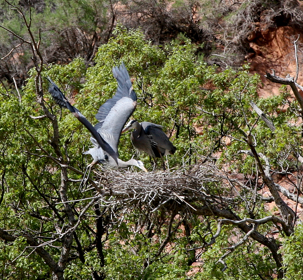
are occupying their rookery - actually called a herony - at milepost 9 on SR 128 (the "River Road" upstream of Moab) in a grove of Gambel oaks on the opposite bank of the Colorado River. I drive this road between my place and the big city of Moab, so this is a favorite place of mine to pull off and observe the activity. Today I captured several good shots with my big lens.
Here's a nesting pair, with the one on the left having just returned from a fishing trip (click images to enlarge):
And no sooner did it arrive, off it goes again:
Note the heron sitting in the adjacent nest, in the lower-left of the image:
I'll strive to take some better images and share them in the future. Meanwhile, learn more about Ardea herodias here.
Here's a nesting pair, with the one on the left having just returned from a fishing trip (click images to enlarge):
And no sooner did it arrive, off it goes again:
Note the heron sitting in the adjacent nest, in the lower-left of the image:
I'll strive to take some better images and share them in the future. Meanwhile, learn more about Ardea herodias here.
Thursday, April 5, 2012
Two unanticipated guests...
have kept me busy the last several days, arriving within a day of my landing at my place in Castle Valley. So, rather than unpacking and cleaning the house and other chores, the former director of the Spokane County Water Quality Management Program Office and his cousin toured the Onion Creek area with me as guide. The peculiar geology of this salt-cored anticline in its early stages of development are spectacularly exhibited in the variegated valley, seen here in a view to the northwest:
This Utah serviceberry bush (Amelanchier utahensis) was pushing out spectacular white blossoms along the riparian zone:
The strongly contorted beds in the Paradox Formation are well exposed in this outcrop, created by the slow deformation of the rising salt diapir (that's me for scale):
Here's a broad view toward the southwest of the Fisher Towers area, with the collapsed center of the Onion Creek salt-cored anticline in the center of the image:
And I can report the pit toilet at the Fisher Towers parking area is clean and well-stocked for the early season:
This Utah serviceberry bush (Amelanchier utahensis) was pushing out spectacular white blossoms along the riparian zone:
The strongly contorted beds in the Paradox Formation are well exposed in this outcrop, created by the slow deformation of the rising salt diapir (that's me for scale):
Here's a broad view toward the southwest of the Fisher Towers area, with the collapsed center of the Onion Creek salt-cored anticline in the center of the image:
And I can report the pit toilet at the Fisher Towers parking area is clean and well-stocked for the early season:
RELATED: Here's the online geologic map and report for the Fisher Towers 7.5' quadrangle (warning: 5.6 MB .pdf file).
Sunday, April 1, 2012
The Swell was swell...
and that's no Aprils' Fools joke. On the way to Utah I spent parts of the last two days exploring the San Rafael Swell, a large Laramide-age sandstone upwarp in south-central Utah. This was the view from my sleeping perch at the edge of the Wedge Overlook at sunrise this morning (click images to enlarge):


My long shadow towards the west accompanies the view of the Little Grand Canyon of Utah, where the San Rafael River has incised deeply into the heart of the structure:

The Buckskin Wash pictograph panel is one of my favorites in Utah, extending more than 100 ft along the base of a wall composed of the Navajo Sandstone:

These anthropomorphic figures with outstretched arms are almost certainly inspired by the phenomena of virga, where falling rain evaporates before striking the surface:

The bridge spanning the San Rafael River was built in 1936, and though no longer in use, stands as a historic monument:
Subscribe to:
Posts (Atom)